
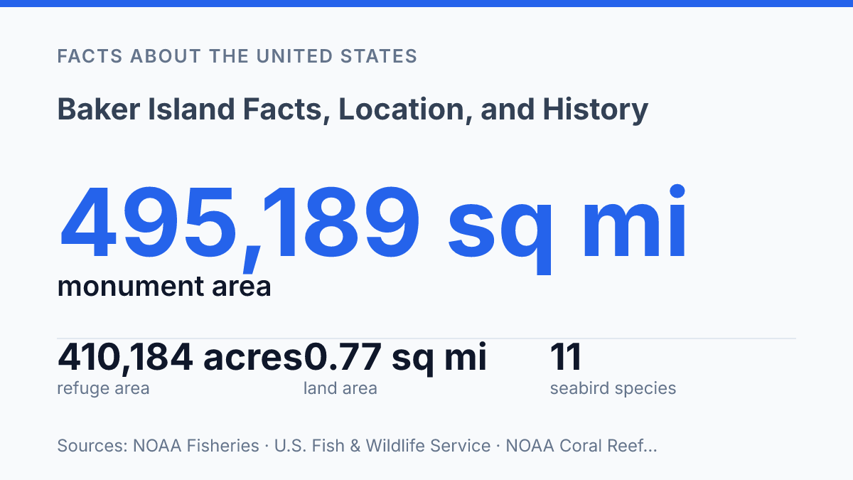
Baker Island covers only 0.77 square miles of land, yet its protected refuge extends across 410,184 acres of reef, seabed, and open-water habitat. That scale difference explains why a place with zero population, no fresh water, and a highest point of about 8 meters carries outsized scientific and conservation value. The island sits just north of the Equator, remote enough that access is limited to permit holders arriving by ship, but historically connected to 19th-century guano claims, Pacific labor routes, and U.S. territorial expansion.
Its story is not only a matter of coordinates and ownership records. The names attached to the island, including the Hawaiian alternative Puakaʻilima, point to a more layered past, while its seabird nesting habitat and surrounding marine protections show why such a small landform remains closely managed.
Where Baker Island Is and Why It Matters
A U.S. territory with zero population and no permanent freshwater lies only 24 kilometers north of the Equator in the central Pacific. Baker Island is commonly grouped with the Phoenix Islands, a remote chain spread across the equatorial Pacific, and sits west of Howland Island and far from any large population center. That position helps explain the island’s unusual profile: it is physically small and uninhabited, yet legally and administratively significant because it anchors U.S. jurisdiction in a wide ocean area.
NOAA lists the island’s land area at 0.77 square miles, underscoring how little dry ground exists above sea level. The island is low, flat, and exposed, with a highest point of about 8 meters, according to the Pacific Islands Benthic Habitat Mapping Center.
Its surface is mostly coral-derived terrain rather than fertile high island land, and the absence of permanent freshwater sources has been a central constraint on settlement. These physical limits are one reason the island has no resident population, even though it has formal territorial status.
Legally, the island is a U.S. unincorporated territory, meaning it is under U.S. sovereignty but is not part of any state and does not have the same constitutional arrangement as an incorporated territory. Day-to-day federal management is carried out through the U.S. Fish and Wildlife Service as part of the Baker Island National Wildlife Refuge, with the surrounding waters managed in the broader Pacific Islands Heritage Marine National Monument framework. NOAA Fisheries describes that wider monument as covering about 495,189 square miles and including seven islands and atolls, which places the island within a much larger federal conservation and ocean-management system.
The scale contrast is central to why the island matters. According to the U.S. Fish and Wildlife Service, the refuge associated with the island covers 410,184 acres, including 531 terrestrial acres and 409,653 acres of submerged habitat inside a 50-nautical-mile boundary created on January 6, 2009.
In practical terms, the island itself is a tiny equatorial landform, but its administrative footprint extends across a much larger marine area. That combination of remoteness, protected waters, and U.S. territorial status gives the island significance well beyond its visible shoreline.
How the Island Got Its Name and U.S. Claim
The island’s present English name records a later claimant, not the first recorded American sighting. The commonly cited early American encounter came in 1825, when Captain Obed Starbuck of the whaling ship Loper sighted the island.
Its later English name is associated with Captain Michael Baker, a New Bedford mariner who, according to NOAA cultural seascape research, visited in 1832 and returned on August 14, 1839, to raise the American flag. That sequence helps explain why Baker Island carries Baker’s name even though Starbuck appears earlier in the sighting record.
Commercial guano interests turned these scattered maritime encounters into a legal claim. The U.S. Guano Islands Act of 1856 allowed U.S. citizens to claim, on behalf of the United States, islands containing guano deposits if they were not occupied and were not under another government’s lawful jurisdiction.
This was a specific statutory pathway rather than a conventional settlement-based annexation, so the claim depended on both private initiative and federal acceptance. In this context, the island’s value lay less in habitation than in guano, a fertilizer resource that drew American and other commercial attention across the Pacific in the nineteenth century.
Federal recognition came after Baker’s private interest had already changed hands. NOAA’s cultural seascape research says Baker sold his interest on September 1, 1855, and that the formal U.S. claim followed in August 1857. That timing places the island within the early use of the Guano Islands Act, while also showing why the path to U.S. control was not simply a matter of discovery.
A 2024 U.S. Fish and Wildlife Service and NOAA assessment adds another layer to the naming history: Hawaiian guano laborers in the 1850s used the alternative name Puakaʻilima, a reference to the ʻilima flower and memories of home. The official American claim history is therefore clear in outline, but the names attached to the island preserve traces of maritime commerce, federal law, and labor history.
Wildlife, Habitat, and Conservation Status
The protected refuge covers 410,184 acres, but only 531 of those acres are land; the remaining 409,653 acres are submerged habitat within a 50-nautical-mile boundary created on January 6, 2009, according to the U.S. Fish & Wildlife Service. That ratio explains why conservation management treats the island and its surrounding waters as one ecological unit rather than as a small patch of land with adjacent ocean. Its status as a National Wildlife Refuge gives formal protection to both nesting habitat above the tide line and reef-associated habitat below it.
On land, the refuge’s ecological value is concentrated in simple but scarce habitat types. A 2007 draft comprehensive conservation plan describes the terrestrial area as nesting habitat for 11 seabird species, divided into roughly 31 acres of beach and beach strand, 300 acres of short grass and forbs, and 200 acres of bare ground. Those sparse surfaces are suitable for ground-nesting and open-site seabirds recorded from the refuge, including sooty terns, brown noddies, and masked boobies.
The surrounding submerged habitat broadens the conservation case beyond seabirds. Reef surveys and federal management documents treat the waters around the island as part of a central Pacific coral-reef system, with coral communities, reef fish assemblages, and other reef-associated organisms tied to shallow hard-bottom habitat. In this setting, the reef is not a scenic fringe around the island; it is the larger protected habitat by area and a major reason the refuge boundary extends far beyond the shoreline.
Limited routine human presence reduces some direct pressures on nesting colonies and reef communities, although isolation does not remove all conservation concerns. Managers still have to account for disturbance risk, invasive species prevention, marine debris, and coral stress from warming seas. The island’s low level of use therefore functions as a management advantage: it helps preserve breeding space and reef habitat while giving scientists a relatively undisturbed reference point for central Pacific wildlife and marine monitoring.
Access, Current Use, and What Visitors Should Know
Legal permission is only the first barrier: federal guidance says entry is limited to permit holders, and the island can be reached only by ship. As of 2026, the U.S. Fish and Wildlife Service states that access is by permit only for agency personnel, scientists, and researchers, according to its public refuge information. That rule makes casual visitation functionally unavailable, even before distance, weather, vessel capacity, and safety planning are considered.
No resident community lives there, and there is no permanent infrastructure supporting habitation, tourism, or routine public use. The practical effect is different from many other U.S.-administered places: legal jurisdiction does not translate into ordinary visitor access. Without lodging, port facilities, emergency services, or maintained visitor amenities, any authorized landing depends on expedition-style logistics arranged for official or scientific purposes.
Modern use is therefore centered on conservation management, research, monitoring, and periodic government visits rather than settlement or recreation. Field activity is generally tied to refuge oversight, biological surveys, habitat assessment, invasive-species precautions, or broader marine-resource management. Limited access also reduces the risk that people, cargo, or vessels introduce disturbance to nesting wildlife or fragile nearshore habitats.
Rules can extend beyond landing on the island itself. NOAA Fisheries’ 2026 permit information for regulated fishing activity in monument waters says both the owner and operator of a vessel must hold the relevant permit, and operators must submit required log sheets within 30 days after each fishing trip.
This does not create a tourism pathway; it illustrates that nearby ocean use is also managed through federal permitting and reporting systems. For practical purposes, the island remains a protected research and conservation site, visited rarely and under tightly controlled conditions.
Why a Nearly Empty Island Carries So Much Weight
A place with no permanent population can still shape policy, science, and historical memory. The island’s future will likely be defined less by settlement or tourism than by the quality of its protection, the precision of its research, and the ability of managers to monitor a low coral island whose highest ground rises only about 8 meters.
Restricted access may make the site feel distant, but that distance is part of the reason its reefs, seabirds, and archival traces remain legible. For researchers and agencies, the practical consequence is clear: every landing, permit, survey, and vessel log carries more weight when the land itself is so small.
Frequently Asked Questions
Q: Where is Baker Island located?
A: Baker Island is a small uninhabited atoll in the central Pacific Ocean. It lies just north of the equator and roughly halfway between Hawaii and Australia, in the Line Islands group. Its remote position is a major reason it has remained largely undisturbed.
Q: Who controls Baker Island today?
A: Baker Island is administered by the United States as an unincorporated territory. It is managed as a wildlife refuge rather than a settled community, so there is no permanent population. Access is tightly limited to protect the island’s ecosystem.
Q: Why is Baker Island uninhabited?
A: The island lacks a natural freshwater source and has very limited soil and vegetation. Those conditions made long-term settlement difficult, especially for sustaining agriculture. Its isolation also reduced its value as a permanent home compared with larger Pacific islands.
Q: What is Baker Island known for historically?
A: Baker Island was claimed by the United States in the 19th century and later used in the early 20th century for guano mining and other strategic purposes. During World War II, it briefly supported military use, which reflects its value as a remote Pacific location. Today, its history is most often discussed alongside its role in U.S. territorial expansion and island ecology.
Q: Can people visit Baker Island?
A: Public visitation is generally not allowed. Because the island is a protected wildlife refuge, entry is restricted to authorized research and management activities. The access rules help preserve nesting birds and other sensitive habitats.