
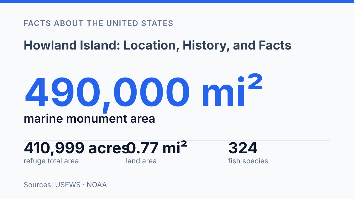
Howland Island occupies only 648 terrestrial acres inside a 410,999-acre national wildlife refuge, a scale contrast that explains much of its modern significance. The island has no resident population, yet the waters around it are protected out to 50 nautical miles and contain recorded populations of 324 fish species, 109 stony coral species, and major seabird nesting areas. Its isolation in the central Pacific also gives the island an outsized historical profile.
U.S. claims under the Guano Act, a short-lived 1935 colonization program, and the unresolved Amelia Earhart flight of July 2, 1937 all connect this small coral island to wider questions about navigation, resource extraction, territorial control, and conservation. The key facts are not only where the island is, but why such a small place is managed with such strict limits today.
Where Howland Island is and who manages it
Howland Island is administered as U.S. territory even though its resident population is zero and almost all of its protected area lies underwater. The island sits in the central Pacific Ocean, just north of the Equator and west of the Phoenix Islands, far from any continental landmass or regular civilian settlement pattern.
In legal terms, it is an unincorporated, unorganized territory of the United States. “Unincorporated” means it is under U.S. sovereignty but is not treated as fully incorporated into the United States for all constitutional purposes, while “unorganized” means Congress has not created a local civilian government for it. Day-to-day federal responsibility rests with the U.S. Fish and Wildlife Service, which manages the island as Howland Island National Wildlife Refuge within the National Wildlife Refuge System.
The physical island is extremely small: broad geographic summaries commonly describe its land area at about 1.6 square miles, and federal refuge accounting identifies 648 terrestrial acres. Its scale is clearer when set against the surrounding protected waters. According to USFWS, Howland Island National Wildlife Refuge totals 410,999 acres, including 648 terrestrial acres and 410,351 acres of submerged lands protected out to 50 nautical miles after the January 6, 2009 monument designation.
That contrast explains the island’s modern administrative character. It is U.S. territory on maps and in federal law, but it is not a municipality, a colony with a resident community, or a place with ordinary public infrastructure. Its management is organized primarily around federal conservation control over a small coral island and a much larger surrounding marine area, rather than around settlement, commerce, or local governance.
Early history and naming
A claim made for bird manure in 1857 later became part of the legal foundation for a U.S. foothold in the central Pacific. Under the Guano Islands Act of 1856, U.S. citizens could claim unoccupied islands containing guano deposits on behalf of the United States, provided the claim met federal requirements.
According to the U.S. Fish and Wildlife Service, Howland was claimed under that law in 1857, and between 85,000 and 100,000 tons of guano were removed before mining ended. The episode explains why a place with little capacity for ordinary settlement acquired federal importance: its value first lay in extractive rights and legal possession rather than in agriculture, commerce, or local population growth.
The island’s name also reflects the maritime networks that brought New England whalers and traders across the Pacific in the 19th century. A U.S. Fish and Wildlife Service conservation plan notes an earlier naming by Captain Daniel McKenzie of the Minerva Smith in 1828, while Captain George E. Netcher of the whaler Isabella is generally credited with applying the present name on September 9, 1842.
That name honored Benjamin Howland of New Bedford, Massachusetts, linking the island to one of the major American whaling ports of the period. Naming was not merely descriptive; in practice, it helped fold distant islands into navigational records, commercial memory, and later territorial claims.
Renewed U.S. interest in the 1930s turned the earlier legal claim into a more active occupation effort. In 1935, the federal colonization program sent young American colonists, many associated with the Hui Panalaʻau program from Hawaii, to maintain a presence and support U.S. claims in the equatorial Pacific.
The settlement effort was austere and difficult, dependent on outside supply and exposed to the practical limits of living on a small, dry atoll. USFWS records state that colonization began in 1935 and ended with wartime evacuation in January–February 1942, showing the gap between legal possession and sustainable habitation.
The Amelia Earhart connection
A final radio transmission at about 8:43 a.m. turned a planned refueling stop into one of aviation history’s most enduring missing-person cases. Amelia Earhart was attempting to fly around the world in 1937 with navigator Fred Noonan, and the island was intended to serve as a critical stop on the long Pacific leg of the journey. On July 2, 1937, their Lockheed Electra was expected to reach Howland Island after departing Lae, New Guinea, but the aircraft never arrived.
The U.S. Coast Guard cutter Itasca had been stationed near the island to support the flight, primarily by providing radio contact and navigational assistance as Earhart and Noonan approached. The arrangement reflected the practical difficulty of finding a very small destination after a long overwater flight, especially with the radio-direction methods and equipment limitations of the period. According to the National Archives, Earhart’s crew reported being 200 miles from the island and flying at 1,000 feet before the final received message from the aircraft’s call sign, KHAQQ, came at about 8:43 a.m.
Search efforts followed, but Earhart, Noonan, and the aircraft were never found. The Itasca’s role in the episode remains central to the historical record because its logs and received transmissions provide some of the clearest documented evidence from the final phase of the flight. Those records establish the outline of the event without resolving its central uncertainties: the aircraft was near its intended destination, radio contact was intermittent and difficult, and the flight ended without a confirmed crash site or recovery.
This association made the island far better known than its physical scale or ordinary administrative history would suggest. Its place in aviation history rests not on infrastructure or settlement, but on its role as the intended destination in a flight that remains unresolved in the public record.
Wildlife, access, and why the island matters now
On just 0.77 square miles of land, the refuge is associated with 324 recorded fish species, 109 stony coral species, and 13 nesting seabird species, according to USFWS and NOAA. That imbalance between tiny land area and broad ecological value explains why the island is treated primarily as protected habitat rather than as a place for ordinary public use. The surrounding shallow reef, which NOAA maps at 0.77 square miles, supports coral-island ecology characteristic of remote central Pacific systems, where seabirds, shorebirds, reef fish, corals, and invertebrates are linked through nutrient flows between land and sea.
As part of the Howland Island National Wildlife Refuge, the island contributes to a wider conservation network rather than standing alone as an isolated preserve. USFWS places it within the Pacific Islands Heritage Marine National Monument, a protected system covering roughly 490,000 square miles and containing seven national wildlife refuges; the monument was renamed in January 2025. This broader designation matters because mobile species, reef systems, and migratory birds are not confined to the island’s shoreline, so conservation depends on protecting surrounding waters as well as nesting and resting habitat on land.
Access rules reflect that conservation purpose. NOAA states that public entry to islands in the monument requires a special-use permit and is generally limited to scientists and educators.
Non-commercial fishing requires authorization under 50 CFR 665, and commercial fishing is prohibited in these protected waters. There is also no maintained civilian infrastructure for routine access, such as visitor facilities or services, which makes the island unsuitable for casual visitation and reinforces its function as a managed refuge.
The same remoteness that shields habitats from heavy human pressure also makes fieldwork, enforcement, and ecological monitoring more difficult. Research visits must account for long travel distances, limited landing options, and the need to avoid disturbing nesting wildlife. For U.S. territorial geography, the island remains significant because it anchors federal conservation responsibilities across a large marine area while demonstrating how even a very small landform can carry outsized ecological and jurisdictional importance.
Why a place with no residents still shapes Pacific policy
The practical lesson from Howland Island is that remoteness does not mean irrelevance. Places with zero population can still affect maritime jurisdiction, species protection, aviation history, and the design of large marine reserves.
Future attention is likely to focus less on settlement or access than on monitoring reefs, seabirds, fisheries pressure, and climate-related change across a protected area far larger than the exposed land itself. That makes the island a useful case study in modern conservation policy: the most closely managed places are not always the most visited, and the smallest landforms can anchor some of the largest protected ocean spaces.
Frequently Asked Questions
Q: Where is Howland Island located?
A: Howland Island is a small, unincorporated U.S. territory in the central Pacific Ocean, near the equator. It lies roughly halfway between Hawaii and Australia, which makes it one of the more remote islands under U.S. jurisdiction.
Q: Is Howland Island inhabited?
A: No permanent population lives on Howland Island. It has no towns, ports, or residential infrastructure, and access is restricted mainly to scientific, conservation, or government visits.
Q: Why is Howland Island historically significant?
A: The island is best known for its connection to Amelia Earhart, who was attempting to land there during her 1937 world flight. That episode made the island a lasting reference point in aviation history and search-and-rescue studies.
Q: What kind of environment does Howland Island have?
A: Howland Island is a low-lying coral island with sparse vegetation and limited freshwater. Its isolation and thin soils limit development, while also making it valuable as a protected habitat for seabirds and marine life.
Q: Can people visit Howland Island?
A: Visits are possible only under tightly controlled conditions, usually for research or conservation work. There are no regular tourist facilities, so access depends on permits, transport logistics, and environmental restrictions.