
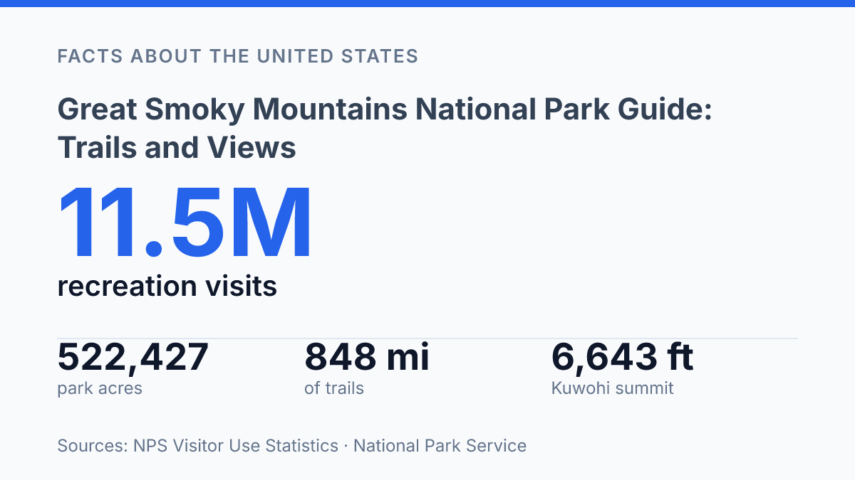
Great Smoky Mountains National Park drew 11,527,939 recreation visits in 2025, yet its 522,427 acres are divided almost evenly between North Carolina and Tennessee rather than centered on a single gateway. That scale helps explain why the park can feel different from one ridge, cove, or trail corridor to the next. The National Park Service identifies 79 vegetation communities here, with eight major forest types covering 96% of the park, so seasonal change is not a uniform event but a sequence shaped by elevation, moisture, and exposure.
Spring ephemerals can appear from February through April at lower elevations, while higher peaks often lag by several weeks. This guide frames the park through its geography, forest cycles, trail and stream networks, Appalachian Trail corridor, and the summit now officially restored as Kuwohi, still widely associated with Clingmans Dome.
Where the park sits on the North Carolina-Tennessee line
Few national parks in the East divide their land so evenly across a state line: Great Smoky Mountains National Park straddles North Carolina and Tennessee rather than belonging clearly to one state. The crest of the southern Appalachians forms much of this political and physical divide, placing the park within reach of communities, highways, and gateway services on both sides of the mountains.
The park was established in 1934, and its protected area is large enough to function as a regional mountain preserve rather than a single scenic destination. The National Park Service lists it at 522,427 acres, or about 800 square miles, divided almost evenly between North Carolina and Tennessee; stated more broadly, the park spans more than 522,000 acres of protected mountain terrain. That scale matters because the park includes long ridgelines, deep coves, river valleys, and high-elevation country within one connected public land unit.
Its border location is one reason the park is so accessible compared with many large mountain parks farther west. Visitors can approach from either state, and major road corridors make short scenic visits possible as well as longer stays in nearby gateway areas.
The same geography also spreads use unevenly: entrances and roads closest to population centers or popular overlooks tend to absorb more traffic than quieter approaches on the far side of the range. Understanding the park as a two-state mountain system helps explain both its convenience and the pressure placed on its most-used access points.
Why the forests and wildflowers change through the year
A single spring date can fall near peak bloom in a low cove while buds remain closed on a high ridge. That staggered timing is one reason the park’s plant life feels unusually changeable: elevation, slope, exposure, and local weather can shift bloom periods by weeks across relatively short distances.
Trails, streams, and the Appalachian Trail corridor
The park’s hiking network is large enough that its nationally known through-trail corridor is only one strand in a much denser web of footpaths. According to the National Park Service, the park contains 848 miles of trail across 150 routes, including 74 miles of the Appalachian Trail within its boundary. That scale matters because route choices range from short waterfall walks to longer creekside climbs and multi-day backcountry passages, rather than centering on a single signature hike.
Water is one of the main features shaping those choices. NPS reports approximately 2,900 miles of streams in the park, a figure that helps explain why so many trails cross bridges, follow drainages, or end at falls.
Laurel Falls is one of the best-known examples, with a relatively short route to a waterfall that draws heavy use. Rainbow Falls offers a longer waterfall hike, while Alum Cave Trail uses a stream corridor and rock features to create a varied route before reaching its better-known upper sections.
The Appalachian Trail corridor gives the park a different hiking function from its day-use waterfall routes. It connects the Smokies to a much longer footpath system and brings through-hikers, section hikers, and day hikers onto some of the same tread. This overlap can concentrate use on access points where national-trail ambitions and short scenic outings begin from the same roads or parking areas.
The same streams and waterfalls that make many routes appealing can also make conditions change quickly. Rain may raise creek levels, slick rock steps, or muddy heavily traveled paths, while popular trailheads can fill early during peak seasons. These pressures do not diminish the quality of the hiking network, but they help explain why the most memorable routes are often shaped as much by water, access, and timing as by distance on a map.
Clingmans Dome and the highest view in the park
At 6,643 feet, Clingmans Dome is high enough that the summit can be wrapped in cloud while lower roads and valleys remain in bright sun. The peak is the highest point in the park, and its observation tower has become the main landmark for visitors seeking the broadest high-elevation view. According to the National Park Service, the summit is reached by a steep paved half-mile walk, a short distance that can feel more demanding because of the grade and altitude.
The tower’s value comes from its elevation and open sightlines rather than from a single framed overlook. From the top, the view opens in all directions across layered ridges, with the blue-gray haze and frequent mist helping explain the Smoky Mountains name. On clear days, the panorama can extend far beyond the immediate ridgelines, but visibility is highly conditional; fog, low clouds, and shifting mountain weather often reduce the view with little warning.
The summit also carries a recent place-name change. On September 18, 2024, the U.S. Board of Geographic Names restored the Cherokee name Kuwohi for the summit formerly known as Clingmans Dome, according to the National Park Service. NPS says the site draws more than 650,000 visitors per year, which places the overlook among the park’s most heavily recognized destinations even though the experience depends strongly on weather and timing.
This combination of altitude, access, and uncertainty is central to the summit’s appeal. The observation tower offers one of the park’s clearest ways to understand the scale of the surrounding mountains, yet the same atmospheric conditions that create the famous smoky appearance can also erase the horizon. For that reason, the summit is both a scenic viewpoint and a reminder that high mountain visibility is never guaranteed.
What the summit name and seasonal numbers reveal
The restored name Kuwohi makes the park’s highest overlook more than a scenic endpoint: it ties a heavily visited summit to Cherokee place history, federal naming policy, and the practical reality of more than 650,000 annual visitors making the steep half-mile walk. The same pattern applies across the park.
A trail choice, bloom window, or October visit is shaped by elevation, crowd pressure, weather, and the economic pull of nearby communities that received more than $2 billion in visitor spending in 2024. The most useful way to read the park is as a connected system, where timing and location change the experience as much as the destination itself.
Frequently Asked Questions
Q: What is the best time of year to see wildflowers in Great Smoky Mountains National Park?
A: Wildflowers bloom year-round in the park, so there is no single peak season for every species. Different elevations and habitats support different plants at different times, which means floral displays can be found across more than one season. This extended bloom pattern is one reason the park is often valued for repeat visits.
Q: Is Great Smoky Mountains National Park on the border of two states?
A: Yes. Great Smoky Mountains National Park straddles the border between North Carolina and Tennessee. That location gives the park access from both states and places much of its terrain along the central Appalachian range.
Q: What kind of hiking trails are in the Smokies?
A: The park includes hiking routes that pass streams, rivers, and waterfalls, which gives many trails a strong water feature component. One segment of the Appalachian Trail also runs through the park. Trail conditions can vary with elevation and weather, so route choice matters for both scenery and effort.
Q: Can visitors get a panoramic view from Clingmans Dome?
A: Yes. An observation tower tops Clingmans Dome, the park’s highest peak, and provides wide scenic views of the surrounding mountains. The view is often shaped by mist, which can soften distant ridgelines and reduce visibility on some days.
Q: Why is the Smokies’ scenery often described as mist-covered?
A: The mountains are frequently seen through mist because the terrain and climate support moisture-rich conditions. That haze can limit long-distance visibility, but it also creates the soft, layered look that many visitors associate with the park. The effect is especially noticeable from higher viewpoints such as Clingmans Dome.