
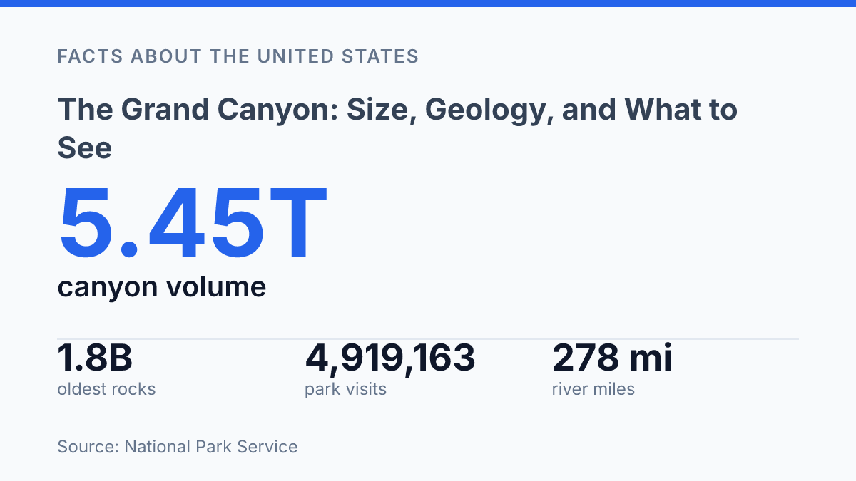
The Grand Canyon exposes rocks from 1.8-billion-year-old Precambrian basement to 230-million-year-old Triassic layers, making its walls a rare vertical record of nearly two billion years of Earth history. Its scale is just as difficult to reduce to a single number: the canyon holds an estimated 5.45 trillion cubic yards of missing rock, yet its width shifts from 18 miles at its broadest point to only 600 feet at Marble Canyon.
The Colorado River established its course through the canyon about 6 million years ago, but erosion, groundwater, springs, and tectonic movement continue to alter the system. This article explains how those forces produced the canyon, what its measurements reveal, what visitors encounter beyond the overlooks, and why the park remains a national benchmark for geology, ecology, recreation, and public value.
How the canyon formed over time
Nearly two billion years of rock are visible in the canyon walls, but the deep chasm itself is far younger than many of the layers it cuts through. According to the National Park Service’s 2026 park statistics, Grand Canyon National Park preserves rocks ranging from 1.8-billion-year-old Precambrian igneous and metamorphic rocks to 230-million-year-old Triassic sedimentary rocks, with younger volcanic deposits as well. That range makes the exposed walls a rare cross-section of Earth history, where stacked sediments, ancient crystalline basement rocks, and later lava flows can be read in vertical sequence rather than inferred only from scattered outcrops.
The canyon’s form resulted from erosion working on uplifted rock, not from a single catastrophic break in the surface. As the Colorado Plateau rose, streams gained the ability to cut downward through layers that had once been deposited in seas, coastal flats, deserts, and river systems. The Colorado River established its course through the canyon approximately 6 million years ago, according to the National Park Service, and its flow began removing rock while tributaries, springs, groundwater, frost, gravity, and tectonic movement continued to widen and reshape the walls.
Layering is central to why the site is scientifically important. The pale Kaibab Limestone, which forms much of the rim in many areas, records a shallow marine environment near the end of the Paleozoic Era, while older units below it reveal different environments and intervals of erosion or nondeposition. Deeper in the sequence, the Grand Canyon Supergroup preserves tilted Proterozoic sedimentary rocks, showing that older episodes of deposition and deformation occurred long before the modern canyon was carved.
Geologists broadly agree that uplift, river incision, and long-term erosion produced the canyon, but the timing and pace of deepening remain subjects of refinement. New dating methods, cave deposits, river gravels, and thermochronology have repeatedly adjusted estimates for when different reaches were cut to their present depths. This does not weaken the core formation model; it shows that the canyon developed in stages, with different segments responding to changing river connections, base levels, climate, and tectonic conditions over millions of years.
How large it is and what those numbers mean
A canyon 277 miles long is long enough to extend beyond the New York–Washington corridor rather than fit into the mental scale of a single park map. According to the National Park Service, Grand Canyon runs for about 277 miles, averages about 10 miles from rim to rim, and reaches about a mile deep. In metric terms, that depth is roughly 1.6 kilometers, a vertical distance comparable to standing a substantial mountain inside the canyon rather than simply looking down from a high overlook.
The average width is useful, but it can make the canyon sound more regular than it is. The National Park Service lists its widest span at 18 miles and one of its narrowest points at 600 feet in Marble Canyon, a contrast that shows why different viewpoints can feel like different places. A 10-mile average suggests a broad metropolitan-scale gap; an 18-mile opening is closer to crossing an entire urban district or suburban corridor in a straight line.
Volume gives another way to understand the scale without adding too many measurements. The National Park Service estimates the canyon’s volume at 5.45 trillion cubic yards, a figure that represents the space carved out rather than a simple surface distance. That number helps explain why the canyon’s size is difficult to grasp from one overlook: its length, width, and depth combine into a landform that is experienced in sections, not as a single view.
What visitors see in the national park
A person can stand at Mather Point minutes after leaving a parking area and look across rock exposures that preserve nearly two billion years of Earth history. In Arizona, Grand Canyon National Park is the main protected area associated with the canyon, and according to National Park Service, 2026, Park Statistics, it preserves rocks from 1.8-billion-year-old Precambrian igneous and metamorphic formations to 230-million-year-old Triassic sedimentary rocks, along with volcanic deposits from 5 million years old to recent time. That range is visible not as an abstract geologic record but as stacked color, texture, shadow, and slope seen from the rim.
The best-known visitor experience is the broad overlook, especially on the South Rim, where places such as Mather Point and Desert View frame long sightlines across buttes, cliffs, side canyons, and the river corridor far below. These viewpoints explain much of the park’s public identity because they make the canyon’s structure legible without requiring a technical background or extended travel into the interior. Desert View also adds a cultural and architectural focal point through its historic watchtower, which links the overlook experience to interpretation of regional Indigenous and park history.
Below the rim, the canyon becomes a far more demanding environment. The Colorado River is not only the feature that draws the eye from many overlooks but also a major white-water corridor through the inner canyon, with rapids shaped by gradient, constricted channels, debris fans, and tributary inputs. Park records for 2025 show 112,319 noncommercial Colorado River user days across two river sections, a figure that indicates how significant river travel is while also distinguishing it from the brief rim-based visit.
Other experiences fill the space between those extremes. Visitors encounter paved rim paths, shuttle-accessible viewpoints, day hikes below the rim, ranger interpretation, mule trips, backpacking routes, desert vegetation, and wildlife adapted to sharp changes in elevation and exposure. The contrast is central to understanding the park as a destination: its most iconic views are easy to reach, while the river corridor and lower canyon require permits, time, physical effort, and careful planning.
Why this site remains a national reference point
The National Park Service counted 4,919,163 visits to the park in 2024, a scale of use that shows why Grand Canyon is managed as a national reference point as much as a scenic destination, according to the agency’s 2024 Visitor Spending Effects report. The same report estimated $905.346 million in visitor spending, supporting 8,778 jobs and producing $1.143 billion in total economic output for nearby economies. Those figures help explain why protection is not only about scenery; it also sustains research, education, recreation, and regional livelihoods.
Much of the canyon and surrounding high country is protected within the national park system, which gives managers a legal framework for maintaining public access while limiting damage to archaeological sites, habitats, and research areas. International recognition reinforces that status: UNESCO designated the park a World Heritage Site in 1979 for its exceptional natural values. The designation reflects why the site is treated as a benchmark for interpreting Earth history and arid-land ecosystems.
For geology education, the canyon’s value lies in visibility. Its exposed strata allow students, researchers, and park interpreters to connect rock relationships, fossils, sedimentary environments, faults, and erosion surfaces with the concept of deep time without relying only on diagrams or core samples. This makes the site unusually effective for public understanding because a rim overlook can introduce principles normally confined to textbooks, while more detailed study supports professional research.
Bright Angel Trail illustrates the balance between access and preservation. As one of the best-known below-rim routes, it concentrates foot travel along a managed corridor where safety messaging, maintenance, and interpretation can be focused. Concentrating use in durable, monitored places helps protect more sensitive areas, although it also places persistent strain on trail surfaces, water infrastructure, sanitation systems, and nearby wildlife.
Cultural significance is part of the same conservation argument, not a separate layer added after the science. The canyon remains connected to Indigenous histories, place names, traditional knowledge, and ongoing relationships with land and water. Managing it as a protected public site therefore involves more than preserving views; it requires treating natural features, cultural resources, and educational access as linked responsibilities.
What the canyon asks of the next century
A canyon that drew 4,919,163 park visits in 2024 is not only a scenic landmark; it is a working measure of how the United States values deep time, public access, and regional economies. Those visits generated about $905.346 million in visitor spending and supported 8,778 jobs, placing preservation and use in constant practical relationship.
The harder question ahead is not whether the canyon is significant, but how a place shaped over millions of years can absorb modern pressure without losing the qualities that make it useful as a scientific record and public space. Its scale makes the site memorable; its limits make management unavoidable.
Frequently Asked Questions
Q: How wide and deep is the Grand Canyon?
A: The canyon averages about 10 miles across and reaches roughly a mile deep along its length. Those dimensions vary from place to place, but they capture the canyon’s overall scale. The width and depth are part of what makes its exposed rock layers so visible from many viewpoints.
Q: How long is the Grand Canyon?
A: It extends for about 277 miles through northern Arizona. That length means the canyon is not a single uniform view, but a long system of cliffs, ridges, and river sections. Different stretches show different rock formations and perspectives on the same geologic history.
Q: Why do the rock layers in the Grand Canyon look so distinct?
A: The canyon’s layered bands of red rock expose a vertical record of geology that spans millions of years. Erosion cut through older rock units and revealed the sequence beneath the surface. That makes the canyon a natural cross-section of Earth history rather than a single rock face.
Q: What can visitors see in the Grand Canyon National Park area?
A: Much of the area is protected as national park land, and the main attractions include sweeping overlooks and Colorado River white-water rapids. Scenic viewpoints are often the most accessible way to appreciate the canyon’s scale. River sections show a different perspective, with steep walls and fast-moving water.
Q: Is the Grand Canyon best seen from the rim or the river?
A: Both offer different information about the canyon. Rim viewpoints emphasize its width, depth, and layered rock walls, while the river highlights its carved passage and rapids. The best choice depends on whether the goal is a broad panorama or a closer view of the canyon’s interior.